A few months ago, we published a short blurb on “where was Pilchuck, WA”? It was prompted by a couple photographs we had, one showing a bird’s-eye view from 1916, the other showing a closer view of Hotel Pilchuck (at lower left in the overall view).

As part of our historical mapping system, we also happened to have a detailed fire insurance map of the Parker-Bell Lumber Co mill, which comprised most of what is seen in the picture. Also seen in the picture are employee houses on the slight hill beyond the mill, the local school beyond the houses, and a double-arch bridge in the distance (just right of center). This small community was 5 1/2 miles north of Arlington, on the Northern Pacific rail line (foreground), which is now our Centennial Trail.
This week, a museum patron stopped in with a set of six pictures (one of which was a duplicate of the above). All of the pictures showed Pilchuck, WA from various angles. It seems amazing that such a robust community could now be completely invisible. The only remaining item is the 1916 bridge, preserved by the county when Highway 9 was re-aligned and a new bridge built to carry modern traffic. Those of you familiar with the area know the old structure as the “Piclchuck Creek Bridge”. Those of you unfamiliar with the area might want to slow down and divert for just a moment to drive across that bridge - you can look in vain for signs of the original community just to the west.

The view above shows the Centennial Trail in light green (left) and the 2012 pre-alignment Hwy 9 at the right with the current (2016) Hwy 9 as a dotted white line (includes a new bridge across Pilchuck Creek). The ground in the center is where Pilchuck, WA used to be, including the huge Parker-Bell Lumber Co mill. The image below is a map, arrows indicating pictures.

Zooming in to get a more detailed view, you can see the hotel, and just below it something marked as an “incline”. The rail tracks, hotel, and bunkhouse sat much higher than the main mill buildings, so the incline was needed to travel back and forth. You can see five boilers in a building at the far right, each with a smokestack. Another pair of boilers in the center have two stacks, and a smaller pair of boilers at the lower right have a single stack. There is also a round domed burner in the upper right that helps in identifying the picture locations.

- Looking toward the houses on the hill. Notice the walkway from the mill to the homes.
- Looking down the incline next to the hotel. Notice the store at the bottom of the ramp.
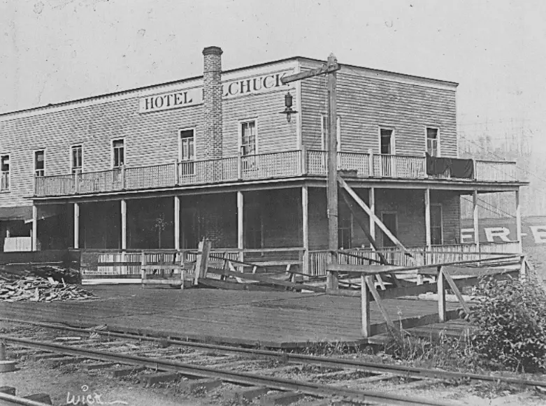
- Looking from across the tracks at Hotel Pilchuck.
- Looking toward the single-stack shingle mill.
- Looking at the log dump.
- (arrow not shown above) Looking down from the houses at the huge lumber yard.
Today, hiking/biking the Centennial Trail takes you right next to this “lost in time” community. See if you can spot any remains of what was once a major area mill. Our thanks go out to Renee Lund for sharing these pictures with us.
Please visit the Granite Falls Historical Museum for glimpses of other Snohomish County “Lost Places”…